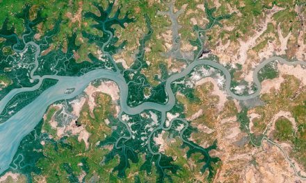
The Institute of Zoology, Zoological Society of London, is searching for a highly motivated research technician to map peatland areas and their biodiversity values using freely available satellite remote sensing information. The successful applicant will be based in Dr Nathalie Pettorelli’s research group and join an exciting inter-disciplinary NERC/Newton/DIPI (Indonesia)-funded project entitled ‘Enhancing the benefits of tropical peatland restoration for supporting local communities and ecosystem processes’. The overall aim of this project is to understand the consequences of draining peatlands for biodiversity and local livelihoods, and to examine different scenarios for prioritising peatlands for restoration, according to biodiversity and emissions considerations and local community benefits and trade-offs. This one year full time position will involve active collaboration with the research groups of Jane Hill and Colin McClean at the University of York, Lindsay Stringer and Keith Hamer at the University of Leeds, Jenny Hodgson at the University of Liverpool, and Fahmuddin Agus and colleagues at the Indonesian Center for Agricultural Land Resources Research & Development, Forest Research & Development Centre, and Jambi University.
Main Duties and Responsibilities
- To conduct satellite remote sensing analyses under the supervision of senior colleagues and to contribute to the production of research
- To support individual and collaborative research projects, duties to include: analysis and interpretation of research data; use of appropriate research techniques and methods; writing up of research results; contributing to the identification of possible new areas of research
- To develop and initiate collaborative working internally and externally, duties to include: the building of internal contacts and participation in internal networks; collaboration with colleagues on joint projects as required; participation in and identification of external networks in order to share information and identify potential opportunities for collaboration and possible sources of funding; attendance at and contribution to relevant meetings
Person Specification
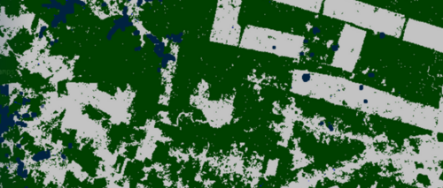
- Experience of multispectral and radar satellite remote sensing data manipulation and analyses with open source software
- Experience of mapping deforestation/forest degradation using satellite information
- Ability to work as part of a team and also to work independently using own initiative
- Experience of writing up research work for publication