“Abstract: In the face of rapid global change it is imperative to preserve geodiversity for the overall conservation of biodiversity. Geodiversity is important for understanding complex biogeochemical and physical processes and is directly and indirectly linked to biodiversity on all scales of ecosystem organization. Despite the great importance of geodiversity, there is a lack of suitable monitoring methods. Compared to conventional in-situ techniques, remote sensing (RS) techniques provide a pathway towards cost-effective, increasingly more available, comprehensive, and repeatable, as well as standardized monitoring of continuous geodiversity on the local to global scale. This paper gives an overview of the state-of-the-art approaches for monitoring soil characteristics and soil moisture with unmanned aerial vehicles (UAV) and air- and spaceborne remote sensing techniques. Initially, the definitions for geodiversity along with its five essential characteristics are provided, with an explanation for the latter. Then, the approaches of spectral traits (ST) and spectral trait variations (STV) to record geodiversity using RS are defined. LiDAR (light detection and ranging), thermal and microwave sensors, multispectral, and hyperspectral RS technologies to monitor soil characteristics and soil moisture are also presented. Furthermore, the paper discusses current and future satellite-borne sensors and missions as well as existing data products. Due to the prospects and limitations of the characteristics of different RS sensors, only specific geotraits and geodiversity characteristics can be recorded. The paper provides an overview of those geotraits.”
Understanding Geodiversity
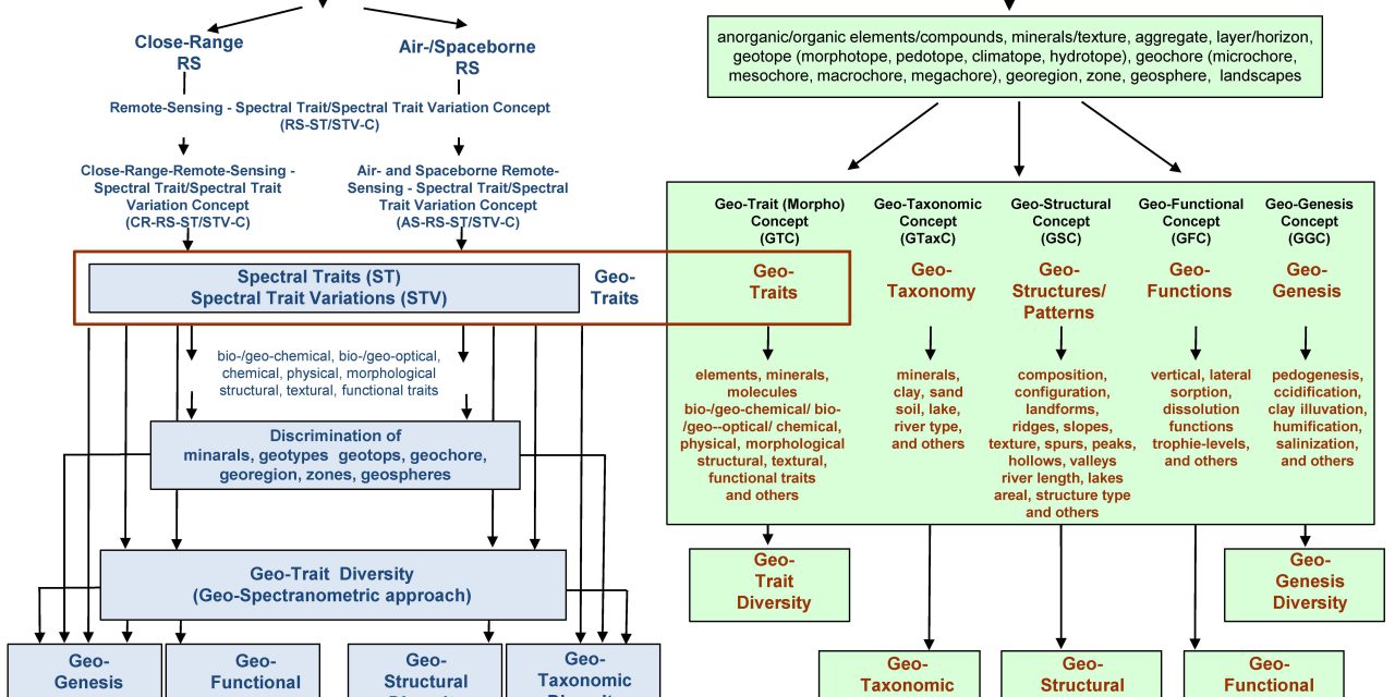
“Geodiversity in this article is defined as the range and variability of geo-components and their intraspecific and interspecific interactions on all levels of organization of their geo-components. Geodiversity comprises components of the atmospheric, the terrestrial, the marine and aquatic ecosystems, and the ecological complexes to which they belong. Geodiversity is described by five characteristics that appear on all levels of organization and interact with each other. These are (see also Figures 1 and 2):
- Geo-genesis diversity – GGD (which is described by the geo-genesis concept – GGC) represents the diversity of the length of evolutionary pathways, linked to a given set of geo-taxa. Therefore, geo-taxa sets that maximize the accumulation of geo-functional diversity are identified.
- Geo-taxonomic diversity – GTD (which is described by the geo-taxonomic concept, GTaxC) – is the diversity of geo-components that differ from a taxonomic perspective.
- Geo-structural diversity – GSD (which is described by the geo-structural concept, GSC) – is the diversity of composition or configuration of 2D to 4D geo-components.
- Geo-functional diversity – GFD (which is described by the geo-functional concept, GFC) – is the diversity of geo-functions and processes as well as their intra- and inter-specific interactions.
- Geo-trait diversity – GTD (which is described by the geo-trait concept, GTC) – represents the diversity of biogeochemical, bio-/geo-optical, chemical, physical, morphological, structural, textural, or functional characteristics of geo-components that affect, interact with, or are influenced by the geo-genesis diversity, the geo-taxonomic diversity, the geo-structural diversity, or the geo-functional diversity” (Lausch et al., 2019).
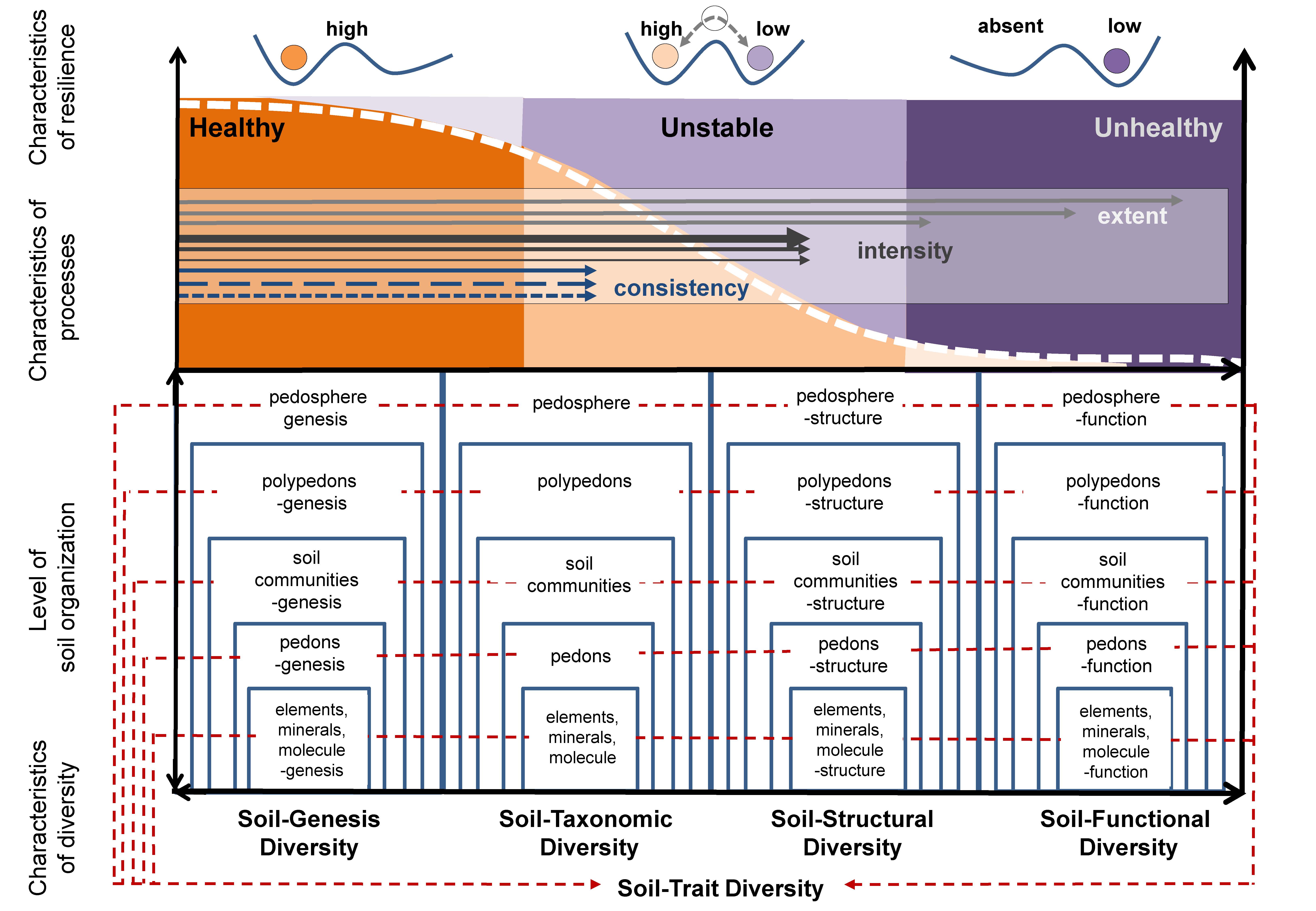
Figure 1. Five characteristics of soil diversity: Soil diversity as part of geodiversity can be described under five characteristics: Soil-genesis diversity, soil-taxonomic diversity, soil-structural diversity, soil-functional diversity, and soil-trait diversity. All of the characteristics involve different levels of soil organization from elements, minerals, molecules, pedons, soil communities, polypedons, up to pedoshere. Different characteristics of the processes (the extent, process intensity, process consistency, resilience, and their characteristics) influence the resilience of soil and ecosystem health (modified after Lausch et al. 2018).
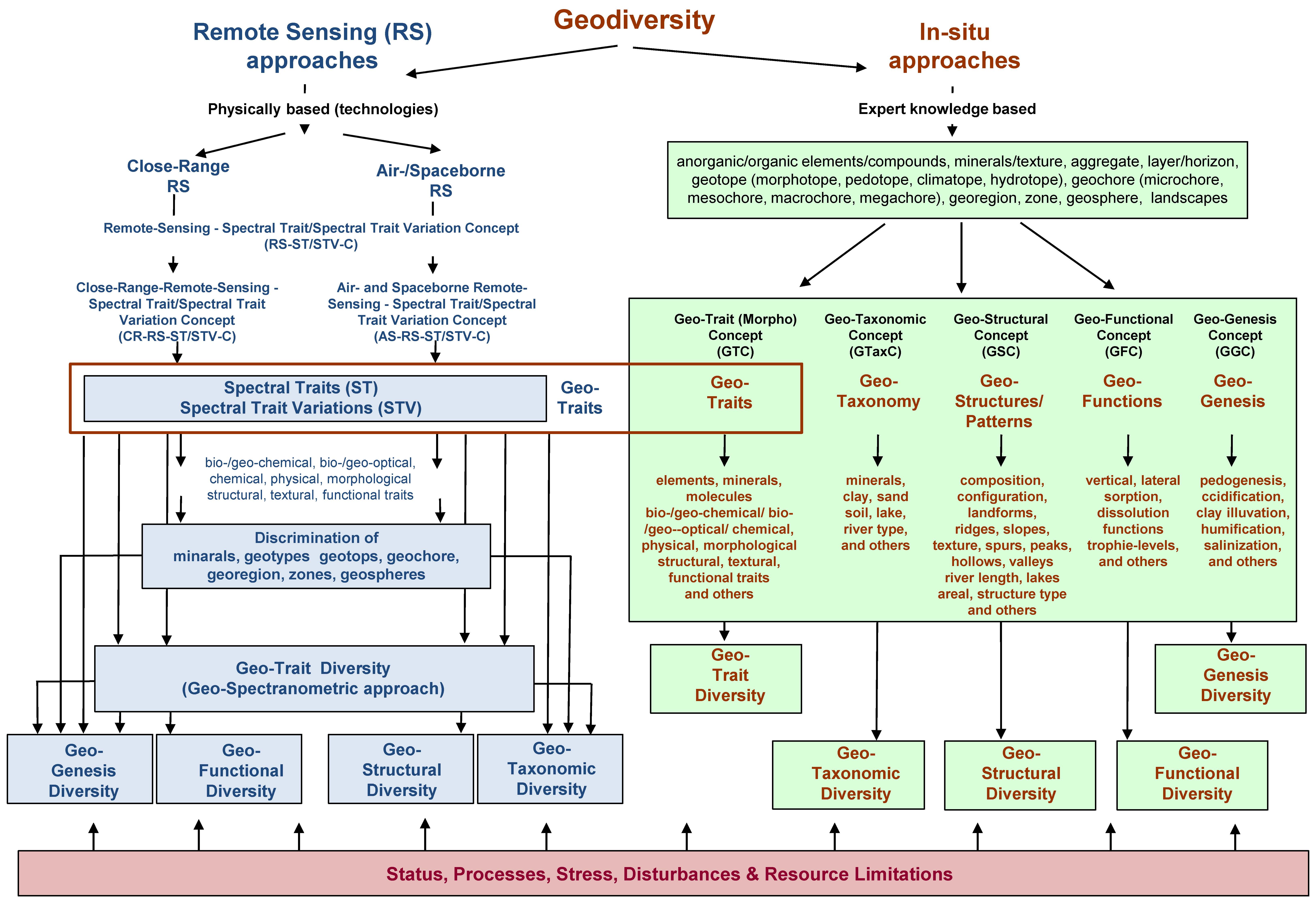
Figure 2. In-situ and remote sensing approaches to monitor geodiversity and their characteristics by remote sensing and in-situ approaches (modified after Lausch et al. 2018)
Lausch, A., Borg, E., Bumberger, J., Dietrich, P., Heurich, M., Huth, A., Jung, A., Klenke, R., Knapp, S., Mollenhauer, H., Paasche, H., Paulheim, H., Pause, M., Schweitzer, C., Schmulius, C., Settele, J., Skidmore, A., Wegmann, M., Zacharias, S., Kirsten, T., Schaepman, M., 2018. Understanding Forest Health with Remote Sensing, Part III: Requirements for a Scalable Multi-Source Forest Health Monitoring Network Based on Data Science Approaches. Remote Sens. 10, 1120. https://doi.org/10.3390/rs10071120