In this paper led by Nicholas C. Coops (see below for citation), Dynamic Habitat Indices (DHIs) are used to capture global terrestrial productivity dynamics.
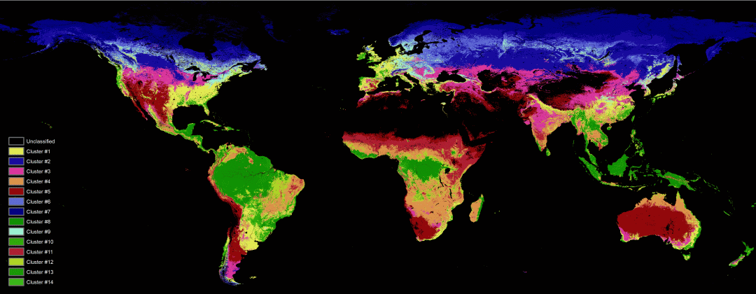
The environmental regionalisation is conducted using an unsupervised two-stage multivariate clustering approach based on global DHI layers produced from over a decade of reflectance data produced by MODIS sensor onboard TERRA and AQUA satellites. The authors also quantify how well this approach can differentiate species richness of key taxa (amphibian, birds and mammals) as well as canopy eight, in relation to conventional regionalisation. In both cases, their clustering approach performs better than conventional maps.
To read the full article or for more information regarding their approach as well as existing caveats in this field, please follow the link to the paper.
Abstract:
Ecological regionalisations delineate areas of similar environmental conditions, ecological processes, and biotic communities, and provide a basis for systematic conservation planning and management. Most regionalisations are made based on subjective criteria, and can not be readily revised, leading to outstanding questions with respect to how to optimally develop and define them. Advances in remote sensing technology, and big data analysis approaches, provide new opportunities for regionalisations, especially in terms of productivity patterns through both photosynthesis and structural surrogates. Here we show that global terrestrial productivity dynamics can be captured by Dynamics Habitat Indices (DHIs) and we conduct a regionalisation based on the DHIs using a two-stage multivariate clustering approach. Encouragingly, the derived clusters are more homogeneous in terms of species richness of three key taxa, and of canopy height, than a conventional regionalisation. We conclude with discussing the benefits of these remotely derived clusters for biodiversity assessments and conservation. The clusters based on the DHIs explained more variance, and greater within-region homogeneity, compared to conventional regionalisations for species richness of both amphibians and mammals, and were comparable in the case of birds. Structure as defined by global tree height was also better defined by productivity driven clusters than conventional regionalisations. These results suggest that ecological regionalisations based on remotely sensed metrics have clear advantages over conventional regionalisations for certain applications, and they are also more easily updated.