In case you are looking for a good and detailed overview of the possible applications of satellite data in natural resource management, this book by Nathalie Pettorelli may be the right choice for you.
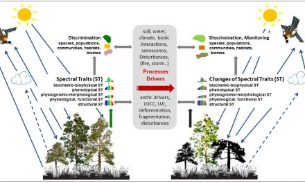
The book first discusses terminology and principals behind remote sensing data and analyses (thus assumes no prior technical knowledge of satellite remote sensing systems and products) and then demonstrates how the combined application of remote sensing and ecological knowledge can help to address a wide array of current natural resource management needs.
Check out the table of contents below for a quick overview and follow this link for further information.
Table of Contents:
1: Understanding satellite remote sensing
2: Satellite-based monitoring of biodiversity
3: Satellite remote sensing and natural disturbances
4: Satellite remote sensing and anthropogenic pressures on biodiversity
5: Satellite remote sensing and the management of invasive species
6: Satellite remote sensing and the management of protected areas
7: Satellite remote sensing and the management of wild species and habitats
8: Satellite remote sensing to support agriculture and forestry
9: Satellite remote sensing, environmental quality and human health and wellbeing
10: Satellite remote sensing in the policy sphere
11: Future directions and challenges ahead