T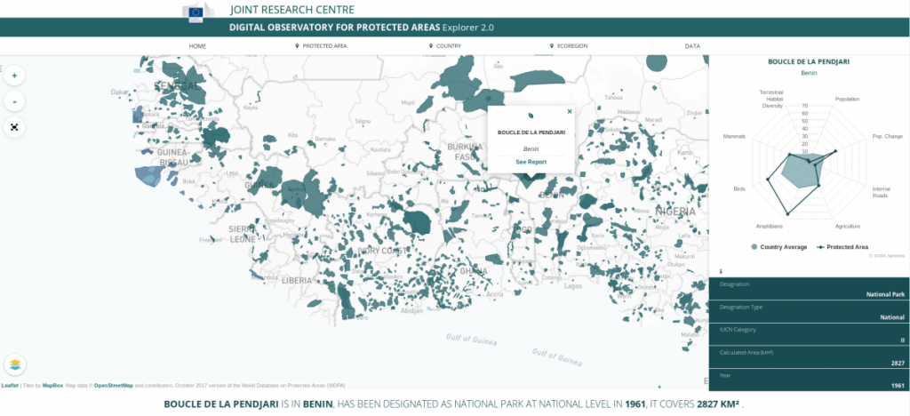 he Joint Research Centre (JRC) of the European Commission has launched the second version of the free DOPA Explorer, the most advanced global information system characterising the world’s protected areas.
DOPA Explorer 2.0, as part of the JRC’s Digital Observatory for Protected Areas (DOPA), assesses the state of and the pressure on nearly 24 000 terrestrial, marine and coastal protected areas. It identifies those protected areas with important ecosystems and species and assesses the pressures they are exposed to because of human activities.
DOPA provides a broad range of consistent and comparable indicators, based on global reference datasets, on protected area coverage, connectivity, species, ecosystems and pressures at country, ecoregion and protected area scale. These indicators are particularly relevant for Aichi Biodiversity Target 11 of the Convention on Biological Diversity (CBD) and the UN Sustainable Development Goals 14 (Life below Water) and 15 (Life on Land) and can support spatial planning, resource allocation, protected area development and management and national and international reporting.
Developed in collaboration with the UN Environment World Conservation Monitoring Centre (UNEP-WCMC), the International Union for Conservation of Nature (IUCN) and BirdLife International, the new release of DOPA Explorer is based on the World Database on Protected Areas (WDPA) of October 2017 and includes a completely revised interface that can be used on multiple devices (PCs, tablets and smartphones).
The indicators in DOPA Explorer 2.0 provide detailed assessments for all protected areas globally that are larger than 50 km2 (covering so 95% of the global surface currently covered by protected areas) and provides site level information on species using information on nearly 23 000 species from the IUCN Red List on Threatened Species TM as well as detailed information derived from earth observations. The more than 400 metrics computed by DOPA also include new indicators on the connectivity of protected area systems as well as indicators derived from Copernicus Earth observation services that highlight changes in the land cover, surface water and built-up areas in protected areas.
For more details about DOPA, please visit us at http://dopa.jrc.ec.europa.eu/
For the technical details regarding the development of DOPA, you will find more information in:
Dubois, G., Bastin, L., Bertzky, B., Mandrici, B., Conti, M., Saura, S., Cottam, A., Battistella, L., Martínez-López, J., Boni, M., Graziano, M. (2016). Integrating multiple spatial datasets to assess protected areas: Lessons learnt from the Digital Observatory for Protected Area (DOPA). International Journal of Geo-Information. http://dx.doi.org/10.3390/ijgi5120242
Bastin, L., Mandrici, A., Battistella, L., Dubois, G. (2017). Processing Conservation Indicators with Open Source Tools: Lessons Learned from the Digital Observatory for Protected Areas. In: Free and Open Source Software for Geospatial (FOSS4G) Conference Proceedings: Vol. 17 , Article 14. August 14-19, 2017, Boston, MA, USA. https://scholarworks.umass.edu/foss4g/vol17/iss1/14/
You can follow us on Twitter at @EU_DOPA