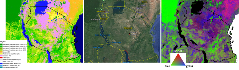
IIASA, Wageningen University and VITO Remote Sensing created (and will continue to provide) global land cover maps. More details from their webpage: To tackle deforestation or loss of biodiversity for example, organizations first have to know the physical coverage of the Earth’s surface, its use and its dynamics. The Copernicus Global Land Services therefore extend its portfolio and released its first Global Land Cover Map to provide spatial information about land for a diversity of applications ranging from global forest monitoring, global crop monitoring, biodiversity and nature conservation to climate modelling. By merging remote sensing imagery with other ancillary data sources, a highly automated, accurate and cost efficient Land Use and Land Cover (LULC) and Land Use and Cover Change (LUCC) solution generates yearly 100 m land cover maps, following the classification scheme of the FAO Land Cover Classification System (LCCS). Next to this basic map, a set of continuous cover layers for tree, grass, shrub and bare soil are generated based on a novel approach. Each cover layer provides the fraction of the pixel that belongs to the given class. Through this information users can combine the layers and tune the default land cover classes for their application, and thus support the United Nations’ Sustainable Development Goals (SDGs). Please see here for further details:
Copernicus Global Land Cover Map