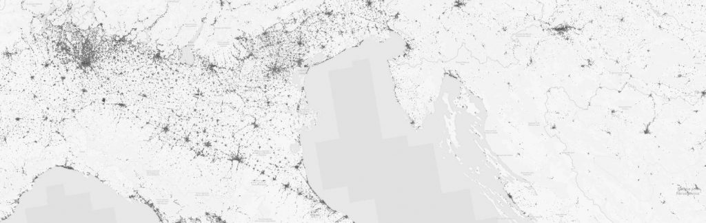

Global Urban Footprint (GUF) by DLR (Thomas Esch) for Italy to Croatia.
The Global Urban Footprint by DLR (Thomas Esch) has been released and provides a global coverage of urbanized areas. From the DLR website: Currently, more than half of the world’s population are urban dwellers and this number is still rapidly increasing. Since settlements – and urban areas in particular – represent the centers of human activity, the environmental, economic, political, societal and cultural impacts of urbanization are far-reaching. They include negative aspects like the loss of natural habitats, biodiversity and fertile soils, climate impacts, waste, pollution, crime, social conflicts or transportation and traffic problems, making urbanization to one of the most pressing global challenges. Accordingly, a profound understanding of the global spatial distribution and evolution of human settlements constitutes a key element in envisaging strategies to assure sustainable development of urban and rural settlements.
In this framework, the objective of the “Global Urban Footprint” (GUF) project is the worldwide mapping of settlements with unprecedented spatial resolution of 0.4 arcsec (~12 m). A total of 180 000 TerraSAR-X and TanDEM-X scenes have been processed to create the GUF. The resulting map shows the Earth in three colors only: black for “urban areas”, white for “land surface” and grey for “water”. This reduction emphasizes the settlement patterns and allows for the analysis of urban structures, and hence the proportion of settled areas, the regional population distribution and the arrangement of rural and urban areas. More details at: www.dlr.de/guf
Further data portals and visualizations are available here:
Via U-TEP Website: https://urban-tep.eo.esa.int
U-TEP Geobrowser: https://urban-tep.eo.esa.int/geobrowser/?id=guf
and a ESA GUF article: http://www.esa.int/Our_Activities/Observing_the_Earth/New_map_offers_precise_snapshot_of_human_life_on_Earth