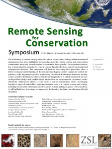
 The ZSL symposium on Remote Sensing for Conservation will take place on the 22nd and 23rd of May 2014 at ZSL in London. This symposium will highlight integrative approaches for an improved ecological understanding of the mechanisms shaping current changes in biodiversity patterns, while triggering new research directions in remote sensing science and the development of new remote sensing products.
Remote Sensing for Conservation: uses, prospects and challenges
Organised by Nathalie Pettorelli, Woody Turner and Martin Wegmann
The conservation of biological diversity is a major public concern. An increasingly strong link is being built between human wellbeing and biodiversity, with the weight of scientific evidence suggesting humans depend on many aspects of biodiversity, particularly the structure and functioning of ecosystems and the services that they provide. The usefulness of remote sensing science to inform conservation biology and environmental management has been highlighted by many; however these two research communities have only recently started to coordinate their agendas. Such synchronization is key to improving the potential for remote sensing data to effectively support environmental management decisions.
This symposium will illustrate how integrative approaches allow a better ecological understanding of the mechanisms shaping current changes in biodiversity patterns, while triggering  innovative approaches, new research directions in remote sensing science and the development of new remote sensing products. It will also demonstrate how ecological knowledge and satellite-based information on environmental conditions can be effectively combined to address a wide array of current conservations needs. By bringing together a range of stakeholders spanning academic experts in remote sensing and ecology, conservation NGOs to policy makers and space agency representatives, it will finally highlight how knowledge exchange is at the heart of the future development of both disciplines.
Outcome: reports, blogs, presentation
A blog entry by N. Pettorelli can be read here: http://methodsblog.wordpress.com/2014/06/04/remote-sensing-for-conservation-uses-prospects-and-challenges/
A twitter storify of the symposium can be accessed here: https://storify.com/RSbiodiv/symposium-remote-sensing-for-conservation
presentations of the symposium can be downloaded here
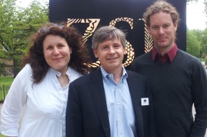
The organisers of the symposium, Nathalie Pettorelli (ZSL, CEOS), Woody Turner (NASA, CEOS, GEO BON) and Martin Wegmann (CEOS @ DLR, Uni Wue) in May 2014, London.
Call for poster and Registration
Please go to to the ZSL symposium webpage to download the call for poster and how to register
Please find the time-table and all talks as well as the registration form here
Dates: 22.-23. May 2014
Venue: ZSL London, UK
List of speakers:
- Compton Tucker, NASA
- Emily Pidgeon, Conservation International
- Graeme Buchanan, RSPB
- Kamran Safi, Max Planck Institute
- Thomas Rabeil, Sahara Conservation Fund
- Roland Brandl, University Marburg
- Thomas Esch, DLR
- Robert Rose, WCS
- Carlo Rondinini, University of Rome
- Ned Horning, AMNH
- Gregoire Dubois, EC-JRC
- Frank Muller-Karger, University of South Florida
- Jonathan Baillie, ZSL
- Diane Davies, NASA
- Peter Reinartz, DLR
- Lucy Bastin, Aston University
- Kate He, Murray State University
- Mike Gill, Environment Canada – GEO BON
- Martin Wegmann, CEOS Biodiversity @ DLR, Dept. of Remote Sensing, Wuerzburg
- Nathalie Pettorelli, ZSL
- Woody Turner, NASA
- Robert Rose, WCS
- and more
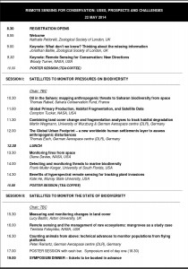 List of talks with preliminary titles:
- Jonathan Baillie
What don’t we know? Thining about the missing information - Woody Turner
Remote Sensing for Conservation: New Directions - Mike Gill, Matt Walpole and Robert Hoft
Earth Observation from a user perspective and to support the implementation
of EBVs and the Aichi targets - Compton Tucker
Global Primary Production, Habitat Fragmentation and Satellite Data - Thomas Rabeil
Oil in the Sahara: mapping anthropogenic threats to Saharan biodiversity from space - Graeme Buchanan (RSPB)
Using remote sensing to inform conservation priorities - Martin Wegmann, Moreno di Marco, Zoltan Szantoi
Combining land cover change and fragmentation analyses to track habitat degradation - Thomas Esch, Martin Wegmann
The global urban footprint a new way to assess and monitor anthropogenic disturbances - Roland Brandl (Univ. Marburg)
LiDAR as a tool to monitor species richness
- Peter Reinartz (DLR)
Counting animals from above – technical advances to monitor populations from flying platforms or satellites
- Diane Davies
Monitoring fires from space - Frank Muller-Karger
Detecting and monitoring threats to marine biodiversity - Kate He
Benefits of hyperspectral remote sensing for tracking plant invasions - Lucy Bastin
Measuring and monitoring changes in land cover - Temilola Fatoyinbo
Remote Sensing and the management of rare ecosystems: mangroves as a case study - Kamran Safi
Predicting vertebrate movement from space to better inform landscape management planning - Nathalie Pettorelli
Unveiling wild animall populations’ secrets using satellite data - Carlo Rondinini
Effectiveness of African protected areas for the conservation of large mammals - Molly Brown
Land cover change, drought and their impact on food security and nutrition outcome - Emily Pidgeon
Satellites and the development of blue carbon initiatives - Mandar Trivedi
Satellites and the implementation of REDD+: a study case from Indonesia - Gregoire Dubois
DOPA, a Digital Observatory for Protected Areasusing Earth Observation - Robert Rose
Identifying the top 10 conservation questions that can be informed by remote sensing - Ned Horning
Integration as the key to success: bridging gaps between ecological research and remote sensing - Martin Wegmann
Conclusion and road ahead
Jointly organised by:
Nathalie Pettorelli (ZSL), Woody Turner (NASA) and Martin Wegmann (CEOS SBA Biodiversity at DLR, LSFE)



past related ZSL Symposia:
Protected Areas – are they safeguarding biodiversity? (link)
overview of the past ZSL symposia (link)
