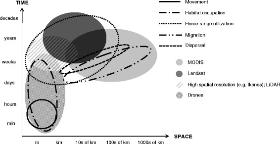
an interesting article published in Movement Ecology covers the opportunities for the application of advanced remotely-sensed data in ecological studies of terrestrial animal movement. Animal movement patterns in space and time are a central aspect of animal ecology. Remotely-sensed environmental indices can play a key role in understanding movement patterns by providing contiguous, relatively fine-scale data that link animal movements to their environment. Still, implementation of newly available remotely-sensed data is often delayed in studies of animal movement, calling for a better flow of information to researchers less familiar with remotely-sensed data applications. Here, we reviewed the application of remotely-sensed environmental indices to infer movement patterns of animals in terrestrial systems in studies published between 2002 and 2013. Next, we introduced newly available remotely-sensed products, and discussed their opportunities for animal movement studies. Studies of coarse-scale movement mostly relied on satellite data representing plant phenology or climate and weather. Studies of small-scale movement frequently used land cover data based on Landsat imagery or aerial photographs. Greater documentation of the type and resolution of remotely-sensed products in ecological movement studies would enhance their usefulness. Recent advancements in remote sensing technology improve assessments of temporal dynamics of landscapes and the three-dimensional structures of habitats, enabling near real-time environmental assessment. Online movement databases that now integrate remotely-sensed data facilitate access to remotely-sensed products for movement ecologists. We recommend that animal movement studies incorporate remotely-sensed products that provide time series of environmental response variables. This would facilitate wildlife management and conservation efforts, as well as the predictive ability of movement analyses. Closer collaboration between ecologists and remote sensing experts could considerably alleviate the implementation gap. Ecologists should not expect that indices derived from remotely-sensed data will be directly analogous to field-collected data and need to critically consider which remotely-sensed product is best suited for a given analysis.
article on the opportunities of remote sensing in animal movement